Bolton Wanderers Football Club Fan Forum for all BWFC Supporters.


You are not connected. Please login or register

Memories of Burnden Park sparked by photo of road opening

5 posters

Go down  Message [Page 1 of 1]

karlypants

karlypants
Nat Lofthouse
Nat Lofthouse

Memories of Burnden Park sparked by photo of road opening 13478984

This photo was released to show Bolton’s new inner relief road shortly before its official opening in December 1971.

The was the eastern stretch of what we now know as St Peter’s Way - a £3.3million project designed to ease traffic congestion around the town.

What many readers will probably find most interesting is the sight of Burnden Park, home of Bolton Wanderers with its floodlights.

Source

Sluffy

Sluffy
Admin

Interesting, thanks for posting this Karly.

It took me a more than a few seconds to work out where this was - yes I know it was of Burnden of course but I was thinking that the picture of the road was St Peters Way and that threw me to begin with.

Actually it isn't as such, the road going over the bridge is St Peters Way, the picture is of the slip road leading on to the north bound carriageway off Raikes Lane.

I went on to google earth just to check that I was right (I've never had need to use that road before so never really realised it was even there) and was quite surprised to see the name of the road was shown as - would you believe - Burnden Road!

I don't think I've ever known before where Burnden Park got it's name from - its always been there and been Burnden Park to me - but I guess the road predates the stadium hence the name!

Am I the last to know about Burden Road or as this come as a surprise to others too?

Norpig

Norpig
Nat Lofthouse
Nat Lofthouse

I didn't recognise the road either and still don't! If that's a new road surely it was named after Burnden Park?

Sluffy

Sluffy
Admin

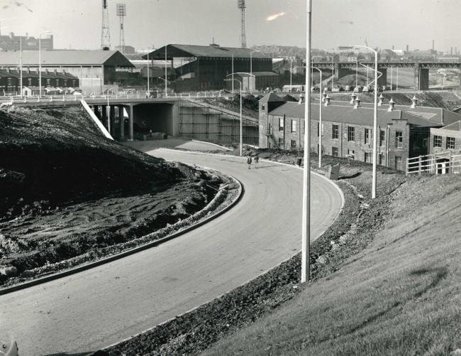
Norpig wrote:I didn't recognise the road either and still don't! If that's a new road surely it was named after Burnden Park?

If you look at the picture St Peters is the road on the bridge that goes behind the back of the ground.  The 'new' road going under the bridge is the access on to St Peters, entering to your left, shortly after you pass where the ground once stood.

I doubt it is an absolutely new road, as there are house showing there that seem to be lower than the road, so I assume they were there first and maybe the original road parallel to it perhaps? Maybe it was just some sort of country lane originally?

Then again why name it as a 'road' which implies it was 'going' to somewhere (Manchester Road, Blackburn Road, Deane Road, etc) when it seems to have been at best some sort of a lane?

The houses are now gone and there doesn't appear to be an old country lane existing there anymore and if you followed where a lane might have been heading away from the ground in the direction of the line of the houses, then it takes you to the canal towpath, so I doubt it was more than a small lane that eventually led to Manchester Road (or to put it another way, just an offshoot from Manchester Road that didn't really lead to anywhere else).

I tend to think there must have been something there because the houses must have had some road/lane/path to them but maybe you are right and the road we see IS mainly new and IS named from the ground rather than the other way about as I was thinking?

..dunno..

boltonbonce

boltonbonce
Nat Lofthouse
Nat Lofthouse

Wasn't the training ground up there. We used to wag off school to watch them.

Sluffy

Sluffy
Admin

boltonbonce wrote:Wasn't the training ground up there. We used to wag off school to watch them.

I don't think so.

The training ground was Bromwich Street - we know that obviously but where abouts exactly was it in relationship to this picture?

Well I've found this...

The white building above the canal embankment is the pavilion of the Bolton Borough Police Sports and Social Club bowling green, football and cricket pitches, which extended along Bromwich Street to Strawberry Hill Road. Bolton Wanderers used it as a training ground.

https://boltonworktown.co.uk/photograph/wasteland

Assuming the bloke who wrote it knew what he was talking about then Strawberry Hill Road lies north of where the ground was and the picture is to the south.

I can't say for certain but I don't think it is where the Bromwich Street Training ground was if that's the area you had in mind?

PS found this also which I think you might find of interest -

https://www.boltonrevisited.org.uk/s-bwfc-1958.html

boltonbonce

boltonbonce
Nat Lofthouse
Nat Lofthouse

Sluffy

Sluffy
Admin


Thanks, I'm from Halliwell and never really knew that part of the town really although I remember my brother driving past it one day for some reason when I was in his car with him.

I remember reading in the BEN about Pele training there as well.

I'm pretty sure that if it is Bromwich Street you were thinking of, then I don't believe it to be the same place as where the St Peters Way picture is.

I don't know if the training ground extended a further distance south so that it might be part of it though?

Might have done?

..dunno..

boltonbonce

boltonbonce
Nat Lofthouse
Nat Lofthouse

Would be nice to climb into a time machine and wander around there for a while. I used to laugh at my dad for his bouts of nostalgia, but I'm just the same now.
The past always seems better when you're getting old. Maybe it was better.

wanderlust

wanderlust
Nat Lofthouse
Nat Lofthouse

Isn't that the slip road off Manny Road by the greyhound track at the Raikes Lane end or am I looking at it from the wrong direction?
It's just that I can see what looks like the railway viaduct in the background before it comes through Burnden in the background in which case the picture may be taken from the south.

Bolton dogs: a shit night out Smile

Memories of Burnden Park sparked by photo of road opening 800px-Raikes_Park_Greyhound_Stadium_in_Bolton_c.1950

Sponsored content


Back to top  Message [Page 1 of 1]

Permissions in this forum:
You cannot reply to topics in this forum